


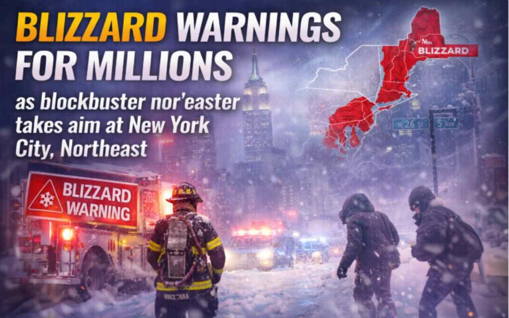
Blizzard warnings for millions as blockbuster nor’easter takes aim at New York City, Northeast. New Yorkers went to sleep earlier this week thinking they might see a manageable dusting of weekend snow. They woke up this Saturday morning to a radically different and far more dangerous reality. The National Weather Service has officially drawn a line in the snow, issuing a severe Blizzard Warning for New York City, Long Island, coastal New Jersey, and coastal Connecticut. What was initially modeled as a glancing blow has rapidly evolved into a historic, blockbuster nor’easter that threatens to paralyze the nation’s largest metropolitan area.
With forecast confidence surging, the storm is expected to undergo explosive intensification—a process meteorologists refer to as bombogenesis—just off the Mid-Atlantic coast. As the system “bombs out” on Sunday, millions of residents along the Interstate 95 corridor will face whiteout conditions, hurricane-force wind gusts, and crippling snowfall rates. While the five boroughs of New York City are bracing for a debilitating strike, meteorologists are warning that Long Island may bear the absolute worst of the storm’s fury, with localized totals potentially exceeding two feet.
The Anatomy of a Bomb Cyclone
To understand why the forecast shifted so dramatically, one must look at the atmospheric mechanics driving this weekend’s monster storm. A nor’easter gets its name from the strong, continuous northeasterly winds that blow in from the ocean ahead of the storm. When a mass of bitterly cold arctic air plunges southward from Canada and collides with the relatively warm, moisture-rich air hovering over the Gulf Stream in the Atlantic Ocean, the atmosphere becomes highly unstable.
This weekend, that collision is expected to trigger a rapid drop in barometric pressure. For a storm to be officially classified as a “bomb cyclone,” its central pressure must drop by at least twenty-four millibars in twenty-four hours. Current forecast models suggest this upcoming system will easily surpass that threshold, deepening violently as it tracks northeastward from the Carolinas toward the waters off the Jersey Shore and Long Island.
This explosive strengthening acts like an atmospheric vacuum, pulling in massive amounts of ocean moisture and throwing it back over the freezing landmass in the form of heavy, blinding snow. The rapid intensification also generates a ferocious wind field, creating the classic blizzard conditions that define the Northeast’s most notorious winter events.
Forecast Models Align for a Worst-Case Scenario
For days, the meteorological community was locked in a tense waiting game. The two primary forecast models used by American meteorologists—the American Global Forecast System and the European model—were locked in a bitter disagreement. Early in the week, the European model depicted a storm tracking further offshore, which would have spared the tri-state area the worst impacts and delivered a mere one to three inches of snow. Conversely, the American model consistently hinted at a track closer to the coast, suggesting a much more severe impact.
By late Friday night and into Saturday morning, the models finally reached a terrifying consensus. The storm’s low-pressure center is now projected to hug the coast, tracking dangerously close to the New Jersey shoreline before pivoting east of Long Island. This is the textbook worst-case scenario for the New York metropolitan area.
Instead of a light, fast-moving system, the region is now staring down a prolonged event. Snow is expected to begin falling Sunday morning, starting as a light wintry mix or rain in areas south of the city before cold air wraps completely into the system, changing all precipitation to heavy snow by Sunday afternoon. The most intense bands of snow will set up Sunday night through Monday morning, delivering snowfall rates that will easily overwhelm local sanitation crews.
Regional Snowfall and Impact Projections
As the storm track has solidified, snowfall projections have skyrocketed. The National Weather Service is not mincing words, warning that travel will become entirely impossible by Sunday evening. Below is a breakdown of the current projected impacts across the tri-state area.
While the official forecast calls for up to eighteen inches across the immediate metropolitan area, localized amounts could be much higher. Private forecasting agencies have noted that if intense mesoscale snow bands stall over specific neighborhoods, the Local StormMax could reach an astonishing twenty-six inches.
Whiteout Conditions and the Wind Factor
A blizzard is not defined strictly by the amount of snow that falls, but rather by the combination of snow, wind, and visibility. To meet the official criteria for a blizzard, a storm must produce sustained winds or frequent gusts of thirty-five miles per hour or greater, accompanied by falling or blowing snow that reduces visibility to under a quarter of a mile for at least three consecutive hours.
This weekend’s storm is expected to easily eclipse those thresholds. As the storm bombs out offshore, the pressure gradient will tighten, generating howling northeasterly winds. Gusts in New York City could reach fifty-five miles per hour, creating a wind chill that plunges into the single digits.
The combination of these winds with snowfall rates of one to three inches per hour will create total whiteout conditions. During a whiteout, drivers lose all sense of spatial awareness; lane markers disappear, the horizon vanishes, and the glow of tail lights is swallowed by the swirling vortex of white. The National Weather Service has explicitly warned residents that anyone caught on the roads during the height of the storm Sunday night will be in a life-threatening situation.
Long Island in the Crosshairs
While the entirety of the tri-state area is bracing for impact, meteorologists are pointing to Long Island as ground zero for the storm’s most devastating effects. Because it juts out into the Atlantic Ocean, Long Island historically takes the first and hardest punch from coastal nor’easters, and this storm will be no exception.
The eastern half of the island, particularly Suffolk County and the twin forks of the Hamptons and Montauk, is expected to endure the absolute heaviest snow bands. The friction caused by the storm’s winds moving from the smooth surface of the ocean to the rougher landmass will enhance lift in the atmosphere, a process that squeezes even more moisture out of the clouds directly over the island.
Furthermore, Long Island faces a severe threat from the ocean itself. The relentless northeasterly winds will pile massive amounts of water against the coastline, acting like a storm surge from a hurricane. A Storm Warning is in effect for the coastal waters, with ocean waves building to twelve to sixteen feet. The National Weather Service is warning of moderate to major coastal flooding during high tide cycles on Sunday night and Monday morning.
Homeowners along the South Shore, Fire Island, and the barrier islands are bracing for significant beach erosion. In areas where dune structures were previously compromised by earlier winter storms, localized overwash is highly likely, threatening beachfront properties and flooding low-lying coastal roadways.
Transportation Networks Grind to a Halt
When the National Weather Service issues a statement reading “Do not travel,” it is not a mere suggestion; it is a definitive line in the sand. The sprawling transportation infrastructure that keeps the New York metropolitan area pulsing is preemptively shutting down to avoid catastrophic stranding.
Major airlines have already sounded the alarm. Carriers including Delta, American, United, Southwest, and JetBlue have proactively issued broad travel waivers for airports across the Northeast, including John F. Kennedy International, LaGuardia, and Newark Liberty International. Thousands of flights scheduled for Sunday and Monday have already been canceled, and airlines are pleading with passengers to utilize mobile apps to rebook flights for later in the week rather than heading to the airport to wait in vain.
On the ground, the situation is equally dire. The Metropolitan Transportation Authority is preparing for emergency operations. While underground subway lines will remain functional as long as power is maintained, above-ground service in the outer boroughs—such as elevated lines in Queens and Brooklyn—will likely be suspended as soon as ice begins to coat the third rail or winds exceed safe operating thresholds.
Major highways, including the Long Island Expressway, the Garden State Parkway, and the New Jersey Turnpike, are expected to become impassable parking lots. State police and transportation departments are warning that plow trucks will not be able to keep up with the extreme snowfall rates. Anyone attempting to drive during the storm’s peak runs the risk of becoming trapped in their vehicle, creating massive logistical nightmares for first responders.
The Looming Threat of Power Outages
Perhaps the most terrifying aspect of a late-February nor’easter is the consistency of the snow. Unlike the dry, powdery snow that falls in sub-zero temperatures, the snow expected on Sunday afternoon and evening will initially be heavy and wet, often referred to colloquially as “heart attack snow” due to the immense physical strain it puts on anyone attempting to shovel it.
When this dense, cement-like snow clings to trees and power lines, the added weight is immense. Combine that weight with wind gusts approaching sixty miles per hour, and the result is snapped tree limbs and downed utility poles. Utility companies across the region, including Con Edison in New York City and PSEG on Long Island, have activated their emergency response protocols and called in mutual aid crews from out of state.
However, utility officials are warning residents to prepare for widespread and potentially prolonged power outages. Because bucket trucks cannot safely be elevated when wind gusts exceed forty miles per hour, repair crews will be grounded during the height of the blizzard. Residents who lose power Sunday night may have to endure freezing indoor temperatures until winds subside on Monday afternoon, making it critical for families to have backup heating plans and ample supplies.
Emergency Response and Government Action
Local and state governments are not taking any chances with this system. Following the chaotic and deadly blizzards of the past decade, emergency management agencies are deploying resources aggressively.
New York State has activated its State Operations Center, with emergency response assets and supplies being moved into position. The State Department of Transportation has mobilized thousands of supervisors and operators, readying a massive fleet of snowplows, salt spreaders, and heavy equipment. Fleet mechanics are staffing maintenance facilities around the clock to ensure trucks stay on the roads.
In New York City, the Department of Sanitation is gearing up for an all-out war against the snow. Brine trucks have already begun treating major thoroughfares, and the city’s vast army of snowplows will be deployed in a synchronized grid to keep essential emergency routes open for ambulances and fire trucks.
New York City Emergency Management has also activated its extreme cold weather protocols. Recognizing the deadly threat posed by plunging temperatures and wind chills, the city has opened warming centers across all five boroughs. Outreach teams are aggressively working to bring unhoused individuals into the shelter system before the blizzard conditions set in.
The Climate Connection to Extreme Winter Weather
While blizzards have always been a part of life in the Northeast, the increasing intensity of these nor’easters points to a changing global climate. As global temperatures rise, the waters of the Atlantic Ocean—particularly the Gulf Stream—are significantly warmer than historical averages.
Warmer ocean water evaporates more rapidly, injecting vast amounts of excess moisture into the atmosphere. When a winter storm taps into this supercharged moisture supply, it acts like a steroid for snowfall. Climate scientists have repeatedly noted that while overall winter temperatures may be rising and producing shorter snow seasons, the snowstorms that do manage to form in the right atmospheric conditions are becoming far more explosive.
This phenomenon explains the “feast or famine” winter cycles New York has experienced over the last decade. The city can go hundreds of days without measurable snowfall, only to be walloped by a historic, record-breaking blizzard that shuts down the region for days. This volatility forces city planners to constantly maintain massive snow-removal budgets, even in years when the plows largely sit idle.
Essential Safety and Preparedness Measures
With the storm’s arrival imminent, the window for preparation is rapidly closing. Emergency management officials are urging residents to take immediate steps to secure their homes and ensure their families are safe.
First and foremost, residents must stay off the roads. The majority of blizzard-related fatalities occur in vehicles when drivers become stranded and succumb to carbon monoxide poisoning or hypothermia. If you absolutely must travel before the storm hits, ensure your vehicle is packed with an emergency kit containing blankets, water, a flashlight, and non-perishable food.
At home, prepare for the very real possibility of losing power. Charge all mobile devices and backup battery banks immediately. Stock up on non-perishable foods that do not require cooking, and ensure you have an adequate supply of necessary prescription medications. If you rely on life-sustaining medical equipment that requires electricity, register with your local utility provider immediately or evacuate to a location with backup generator power.
If you lose heat, close off unneeded rooms to conserve warmth. Dress in multiple, loose-fitting layers and wear a hat indoors to prevent body heat from escaping. Under no circumstances should residents use gas ovens, charcoal grills, or outdoor generators inside their homes or garages to generate heat, as this creates a deadly and silent risk of carbon monoxide poisoning.
Finally, when the storm passes and it is time to dig out, do so with extreme caution. The heavy, wet nature of this snow is notoriously dangerous for individuals with underlying heart conditions. Shovel in short intervals, take frequent breaks, stay hydrated, and check on elderly or vulnerable neighbors who may be trapped in their homes.
The Wait Begins
As Saturday evening descends, the frantic rushing at grocery stores and hardware shops is giving way to an eerie, waiting silence. The sky is thickening with ominous gray clouds, and the temperature is steadily dropping. The tri-state area has prepared as much as humanly possible, but against the raw, explosive power of a bomb cyclone, concrete and steel can only do so much. New York City and Long Island are about to be put to the ultimate winter test. Now, all there is left to do is hunker down, stay inside, and listen to the wind.
Conclusion: The Final Preparations as the Clock Runs Out
As the tri-state area stares down the barrel of a historic bomb cyclone, the time for speculation has ended, and the window for preparation is rapidly slamming shut. The convergence of a plunging Arctic air mass with the unseasonably warm waters of the Atlantic is about to unleash a meteorological fury rarely seen even in the battle-tested Northeast. With Long Island directly in the crosshairs for the heaviest snow bands and coastal devastation, and New York City bracing for total transit paralysis, this storm demands absolute respect.
The narrative of this weekend is no longer about whether it will snow, but rather how successfully millions of residents can weather the ensuing blackout conditions, hurricane-force winds, and crippling snowfall rates. Local and state emergency management agencies have mobilized every available asset, but the raw power of a rapidly deepening nor’easter means that, for a period of time, residents will be entirely on their own.
As the first flakes begin to fly and the barometric pressure plummets, the message from officials is unified and stark: stay off the roads, secure your homes, and check on your vulnerable neighbors. The blizzard of February 2026 is poised to etch its name into the record books. How the region recovers will depend entirely on the precautions taken in these final, fleeting hours of calm.
Frequently Asked Questions: Understanding and Surviving the Blizzard
What exactly is a “bomb cyclone” or “bombogenesis”?
A bomb cyclone occurs when a mid-latitude storm undergoes a rapid and violent drop in atmospheric pressure—specifically, a drop of at least twenty-four millibars in twenty-four hours. This explosive strengthening, known as bombogenesis, acts like an atmospheric vacuum. It pulls in massive amounts of ocean moisture and generates incredibly destructive, hurricane-force winds, turning a standard winter storm into a blinding, paralyzing blizzard.
Why is Long Island expected to get hit harder than the rest of the state?
Geography plays a cruel role in nor’easters. Because Long Island juts out into the Atlantic Ocean, it serves as the physical barrier between the storm’s oceanic moisture source and the mainland. As the moisture-rich air slams into the friction of the island’s landmass, it creates enhanced atmospheric lift, squeezing out heavier, more intense snow bands over Suffolk and Nassau counties. Additionally, the island’s exposed shores take the direct, unmitigated brunt of the coastal storm surge and wave action.
How is a blizzard officially defined?
Contrary to popular belief, a blizzard warning is not triggered by snowfall totals. A storm is officially classified as a blizzard when it produces sustained winds or frequent gusts of thirty-five miles per hour or greater, combined with falling or blowing snow that reduces visibility to less than a quarter of a mile for at least three consecutive hours.
What should I do if my home loses power during the storm?
If the heavy, wet snow and high winds snap power lines, immediate heat conservation is critical.
-
Isolate: Choose one small room to shelter in and close off all other doors.
-
Insulate: Hang blankets over windows to trap ambient heat and block drafts.
-
Layer up: Dress in multiple layers of loose clothing, and wear a hat indoors to prevent body heat from escaping.
-
Protect Pipes: Allow a slow trickle of water to run from your faucets to prevent pipes from freezing and bursting.
Is it safe to use a generator or my gas oven for heat? Absolutely not.
Never use a gas oven, charcoal grill, camping stove, or portable gas generator indoors, in a garage, or even near an open window. Doing so releases odorless carbon monoxide, which is deadly. Portable generators must be operated outdoors, at least twenty feet away from your home, with the exhaust pointing away from any doors or vents.
Can I drive if I have a four-wheel-drive vehicle?
Emergency officials strictly advise against all travel, regardless of your vehicle’s capabilities. During whiteout conditions, visibility drops to zero, making it impossible to see the road, other stranded vehicles, or even the hood of your own car. Furthermore, stranded civilian vehicles block the paths of emergency responders and snowplows. If you become stuck, you are at severe risk of hypothermia or carbon monoxide poisoning if your exhaust pipe becomes blocked by snow.
What is “heart attack snow”?
This is a colloquial term for the heavy, wet snow often produced by coastal nor’easters when temperatures hover near the freezing mark. Because of its high water content, this snow is incredibly dense and heavy. Shoveling it places severe, sudden strain on the cardiovascular system, leading to a spike in medical emergencies. If you must shovel, take frequent breaks, stay hydrated, and do not overexert yourself.